


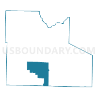
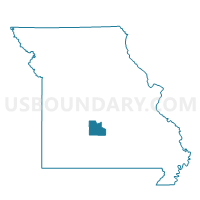
Washington Voting District, Laclede County, Missouri
About
Outline

Summary
| Unique Area Identifier | 608911 |
| Name | Washington Voting District |
| County | Laclede County |
| State | Missouri |
| Area (square miles) | 44.78 |
| Land Area (square miles) | 44.62 |
| Water Area (square miles) | 0.16 |
| % of Land Area | 99.63 |
| % of Water Area | 0.37 |
| Latitude of the Internal Point | 37.56083110 |
| Longtitude of the Internal Point | -92.61364970 |
Maps

Graphs
Select a template below for downloading or customizing gragh for Washington Voting District, Laclede County, Missouri


Neighbors
Neighoring Voting District (by Name) Neighboring Voting District on the Map
- Conway Voting District, Laclede County, MO
- Delto Voting District, Laclede County, MO
- East Lebanon No. 2B Voting District, Laclede County, MO
- Grovespring Voting District, Wright County, MO
- Oakland Voting District, Laclede County, MO
- Phillipsburg No. 1 Voting District, Laclede County, MO
- Phillipsburg No. 2 Voting District, Laclede County, MO
- Spring Hollow No. 1 Voting District, Laclede County, MO
- West Lebanon No. 2 Voting District, Laclede County, MO
Top 10 Neighboring County Subdivision (by Population) Neighboring County Subdivision on the Map
- Lebanon township, Laclede County, MO (18,580)
- Spring Hollow township, Laclede County, MO (4,139)
- Phillipsburg township, Laclede County, MO (1,807)
- Union township, Laclede County, MO (1,755)
- Osage township, Laclede County, MO (1,733)
- Washington township, Laclede County, MO (1,540)
- Union township, Wright County, MO (1,231)
- Franklin township, Laclede County, MO (748)
Top 10 Neighboring Place (by Population) Neighboring Place on the Map
Top 10 Neighboring Elementary School District (by Population) Neighboring Elementary School District on the Map
Top 10 Neighboring Unified School District (by Population) Neighboring Unified School District on the Map
- Lebanon School District, MO (24,821)
- Hartville R-II School District, MO (4,468)
- Laclede County R-I School District, MO (4,462)
Top 10 Neighboring State Legislative District Lower Chamber (by Population) Neighboring State Legislative District Lower Chamber on the Map
Top 10 Neighboring State Legislative District Upper Chamber (by Population) Neighboring State Legislative District Upper Chamber on the Map
Top 10 Neighboring 111th Congressional District (by Population) Neighboring 111th Congressional District on the Map
Top 10 Neighboring Census Tract (by Population) Neighboring Census Tract on the Map
- Census Tract 9601, Laclede County, MO (8,360)
- Census Tract 9603, Laclede County, MO (7,150)
- Census Tract 9602.98, Laclede County, MO (6,053)
- Census Tract 4901, Wright County, MO (3,820)